Gylis
4.0star
197 reviews
10K+
Downloads

Everyone
info


About this app
The app is intended for fishermen, ice fishing enthusiasts, divers and travelers - everyone who wants to get to know their land!
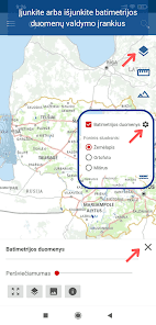
BATHYMETRY
A business card of a water body is a bathymetric plan, which shows the relief of the underwater part (bowl) of the water body trough with lines (isobaths) connecting points of equal depth. In the application you will find bathymetric plans of 300 Lithuanian water bodies. Some plans are published for the first time. Some of the information on the plans is of an overview nature. Digital versions of the bathymetric maps are produced from originals collected by the Climate and Water Research Laboratory, Institute of Geology and Geography, Natural Research Center, Environmental Protection Agency. The data of the Kaunas Lagoon and the Curonian Lagoon were provided by the Directorate of Inland Waterways. Water bodies are mapped by digital JV "GIS-centras" cartographers, students of the Lithuanian University of Education (LEU) majoring in geography.
DATA
In the app you will find bathymetric plans of more than 300 Lithuanian water bodies. Complete list of water bodies in this link -
https://www.geoportal.lt/geoportal/pradziamokslis/-/asset_publisher/fCyjXGTvnYyt/content/vidaus-vandenu-batimetrijos-duomenu-rinkinio-vandens-telkiniu-sarasas
FUNCTIONS
Using this app you can:
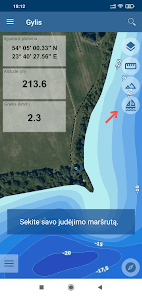
- Find your location on the map
- Select different map layers
- Choose to view the bathymetry of a water body from the list of 300 water bodies.
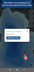
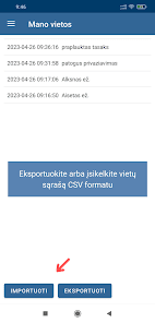
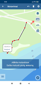
- Mark your places on the map (places where you caught impressive catches; places where you left equipment)
- Find a place by coordinates
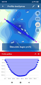
- Measure the bottom profile of the lake
- Perform length and area measurements
- Track your route
The app is designed for mobile devices with Android OS.
The program requires an internet connection.
https://www.geoportal.lt
giscentras.app@gmail.com
BATHYMETRY
A business card of a water body is a bathymetric plan, which shows the relief of the underwater part (bowl) of the water body trough with lines (isobaths) connecting points of equal depth. In the application you will find bathymetric plans of 300 Lithuanian water bodies. Some plans are published for the first time. Some of the information on the plans is of an overview nature. Digital versions of the bathymetric maps are produced from originals collected by the Climate and Water Research Laboratory, Institute of Geology and Geography, Natural Research Center, Environmental Protection Agency. The data of the Kaunas Lagoon and the Curonian Lagoon were provided by the Directorate of Inland Waterways. Water bodies are mapped by digital JV "GIS-centras" cartographers, students of the Lithuanian University of Education (LEU) majoring in geography.
DATA
In the app you will find bathymetric plans of more than 300 Lithuanian water bodies. Complete list of water bodies in this link -
https://www.geoportal.lt/geoportal/pradziamokslis/-/asset_publisher/fCyjXGTvnYyt/content/vidaus-vandenu-batimetrijos-duomenu-rinkinio-vandens-telkiniu-sarasas
FUNCTIONS
Using this app you can:
- Find your location on the map
- Select different map layers
- Choose to view the bathymetry of a water body from the list of 300 water bodies.
- Mark your places on the map (places where you caught impressive catches; places where you left equipment)
- Find a place by coordinates
- Measure the bottom profile of the lake
- Perform length and area measurements
- Track your route
The app is designed for mobile devices with Android OS.
The program requires an internet connection.
https://www.geoportal.lt
giscentras.app@gmail.com
Updated on
Safety starts with understanding how developers collect and share your data. Data privacy and security practices may vary based on your use, region, and age. The developer provided this information and may update it over time.

No data shared with third parties
Learn more about how developers declare sharing

No data collected
Learn more about how developers declare collection
Ratings and reviews
4.0
197 reviews

Mindaugas Vitkauskas
- Flag inappropriate
- Show review history
September 27, 2020
Viskas Ok, bet kada po galais sukursite programele skirta apple irenginiams.
10 people found this review helpful
GIS-Centras
October 1, 2020
Dėkui už susidomėjimą! Artimiausiu metu iOS aplikacijos neplanuojame.

Rolandas Lupeikis
- Flag inappropriate
August 31, 2020
veikia be trikdžių, tik žemėlapiai nėra labai tikslūs
1 person found this review helpful

A Google user
- Flag inappropriate
- Show review history
December 28, 2018
nusivyliau, zemaitijos ezeru realiai 0
12 people found this review helpful
What's new
Galimybė įjungti/išjungti batimetrijos žemėlapio užpildymą spalva ir kitus sluoksnius. Galimybė eksportuoti/importuoti išsaugotų vietų sąrašą CSV formatu. Galimybė peržiūrėti naudojimosi demonstraciją. Atnaujintas įrankių išdėstymas.